Entry Points:

About Adair
Adair sits on a hill that forms the divide between the Mississippi River drainage and that of the Missouri River. In 1868, the Rock Island Railroad was built, passing through the hill in a cut some forty feet deep. The community was then called Summit Cut. On August 20, 1872, it was incorporated and given the name Adair, which it shares with the county it is in. It is named after General John Adair, who served in the War of 1812, and was later the 8th governor of Kentucky. The north boundary of the county passes through Adair, and the top portion of the town is in Guthrie County.
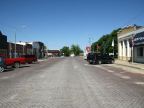
Many of the streets of Adair were paved in cobblestone style, using red bricks, much of which still survives today.
Adair has a population of 839, as of the 2000 census, a size which it has never varied from very much since the late 1800s. U.S. Highway 6 used to pass through Adair on Broad Street and then turning north on Fifth Street. Interstate 80 was built, passing by on the south edge of town, and now U.S. Highway 6 is combined with the freeway.
The elevation at Adair ranges from about 1,400 to 1,480 feet, with the center of the town being built at the top of the hill, and the railroad passing by just south of it. The area receives around 35 inches of rain annually, an ample supply for lush green vegetation and farmland.
For More Information:
See the Wikipedia article on Adair.